
WA Mining Map
A free, live map of mining in Western Australia. Every mining, exploration and prospecting tenement in the state, every mine and deposit on MINEDEX, layered over geology, geophysics, satellite mineral maps and the open-file exploration archive, and rebuilt from the departmental registers every night.
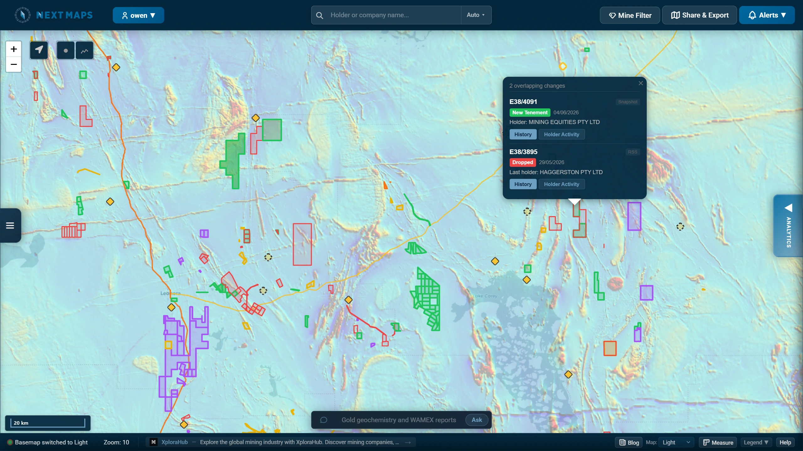
Coverage at a glance
- Tenements mapped
- 30,461 mining, exploration, prospecting and miscellaneous licences
- Local government areas
- 115 shires and cities across Western Australia
- Register last synced
- 7 Oct 2026
- What it costs
- Browsing WA tenure on the map is free and needs no account. A free account adds geology, geophysics, mines, WAMEX, the pegging grid and land access; geochemistry, filtering and mineral mapping are Premium; Sentinel-2 imagery, Tenure Packs and Data Rooms are Pro.
What is on the map
Most WA mining maps show one thing: tenure, or geology, or a printed overview of operating mines. This one layers them together, because the question that actually gets asked is what is on this ground, and can I get it.
- Mining tenureFree
- Every live, pending and recently dead mining lease, exploration licence, prospecting licence, retention licence and miscellaneous licence in WA, with holder, grant date, expiry and area. No account needed to browse it.
- Geology and structureFree account
- GSWA bedrock, interpreted bedrock, Cenozoic, regolith, state linear structures and the 100k and 250k geological series maps, so structure and tenure sit in one view instead of two browser tabs.
- GeophysicsFree account
- Gravity at 400m, magnetics at 80m in TMI, RTP and 1VD, and radiometrics in KTU, potassium, thorium and uranium, for reading structure and lithology under cover.
- Mines and depositsFree account
- MINEDEX mine and deposit locations, operating and abandoned mines, major resource projects, mining residue areas and mineral fields, so producing ground reads at a glance alongside the tenure around it.
- WAMEX exploration reportsFree account
- The open-file exploration archive footprinted over the ground it covers, so you can see who has worked an area and what they were chasing before you peg it.
- DrillholesFree account
- Open-file drillhole collars across the state, searchable by hole ID.
- Pegging grid and dead groundFree account
- Graticular blocks at 5 minute and 1 minute, the grid applications are actually pegged on, plus the dead tenement layer for ground that has already been given up.
- Constraints and land accessFree account
- Native title determinations, ILUAs and NNTT claims, Aboriginal heritage from DPLH, pastoral stations, DBCA conservation areas and the section 19 and 57(4) restricted areas: the overlays that decide whether ground is workable in practice.
- GeochemistryPremium
- 10.2 million surface geochemistry points across more than 70 elements, and drillhole maximum values from 2.5 million holes, filterable by element and by commodity.
- FilteringPremium
- Cut the map down to what you are actually looking for: tenure by type, status and date, WAMEX by date and report content, and MINEDEX by commodity and site type.
- Satellite mineral mappingPremium
- ASTER mineral maps and fourteen EnMAP hyperspectral mineral-group products covering the state: iron oxides and gossan, clay and AlOH alteration, white mica, chlorite, carbonate and silica, plus mineral-index and PCA composites. Coverage footprints are free to browse.
- Sentinel-2 imageryPro
- Timestamped, cloud-free Sentinel-2 over any ground in WA at any date, with mineral-ratio composites for gossan, ferric iron and clay alteration alongside true colour and SWIR.
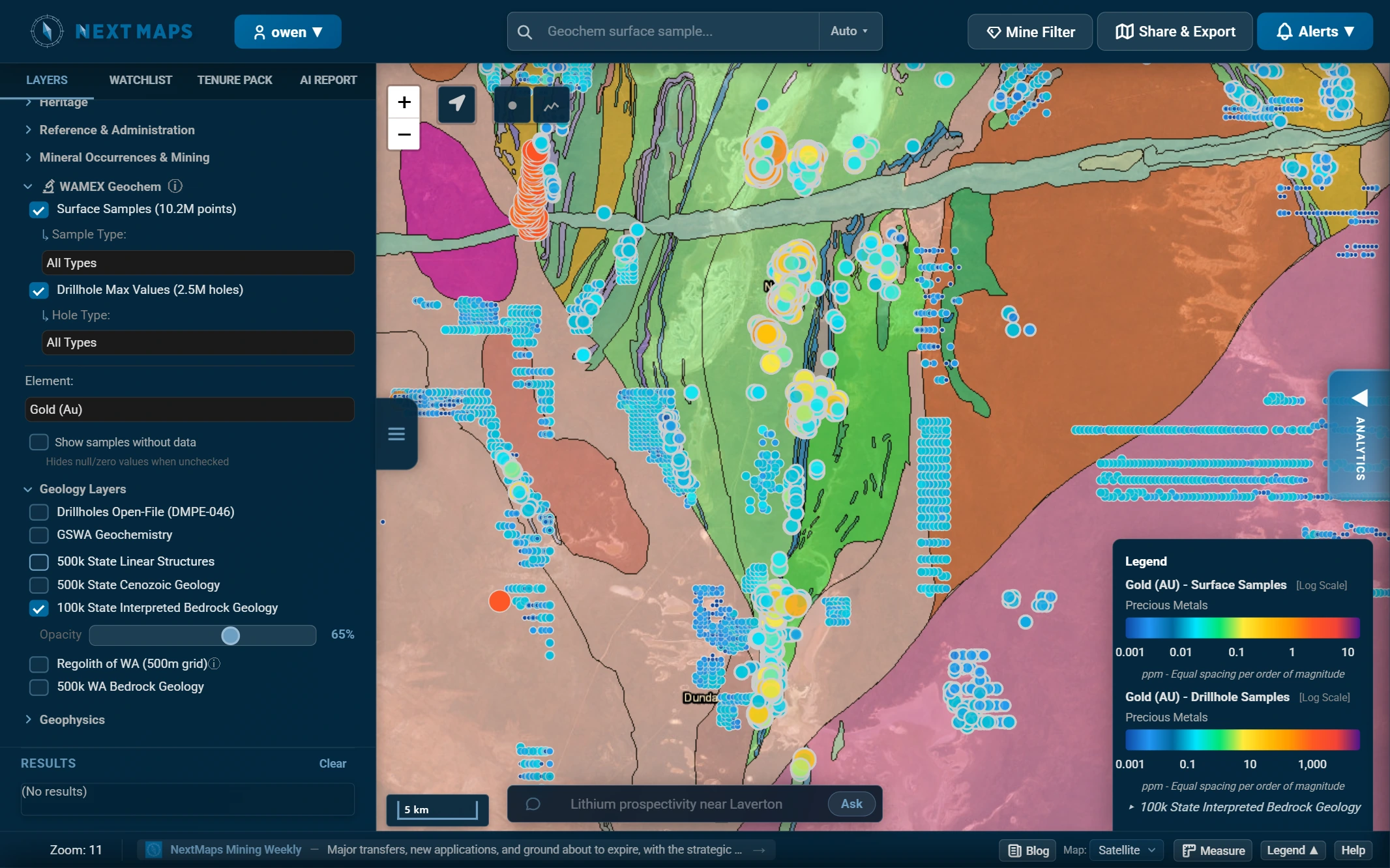
The map reads the register for you
Tenure on its own tells you who holds what. The same records, read daily, also say who is under pressure and where ground is about to come free. Those readings are colourable layers on the map, and every flagged tenement shows its working rather than a black-box score. These are paid layers, unlike most of what is above.
- Distressed tenements
- Forfeiture applications, overdue rent, severe underspend, expiring with no renewal.
- Ground release zones
- Where supply is opening up, lapsing or being surrendered, ahead of formal gazettal.
- Before the Warden
- Tenements with a matter listed in the Warden's Court, including ballots for contested ground.
- Expenditure compliance
- Actual spend against the minimum obligation, so underspend is visible before it becomes forfeiture.
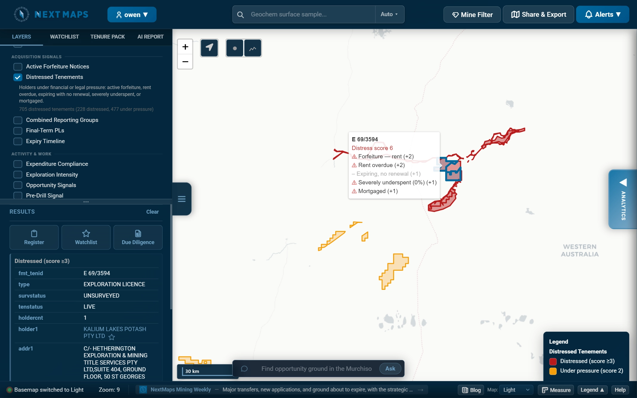
All the Tenement Intelligence layers, including expiry timeline, recent transfers, ownership age, encumbrances, conversion pipeline, application hotspots and exploration intensity.
What you can take away from it
Looking is one job; producing something a board, a financier or a vendor will accept is another. These are the outputs the map feeds, and the part neither government viewer attempts.
- Tenure PacksPro
- The full due-diligence record for a tenement or a whole portfolio: register detail, tenure history, dealings, conditions, expenditure and the spatial data, compiled into one pack instead of a week of compiling. Regenerate any pack on demand as the register moves.
- Prospectivity Data RoomsPro
- Point at a tenement or an area and get a referenced desk study read out of the WAMEX archive: drillhole collars, assays, geology logs and surface geochemistry compiled, with the original A-file PDFs it was built from. Grounded in the record; the judgement stays with you.
- Announcement-quality map exportsPremium
- Map images and PDFs with your own logo and colours, the legend built from whatever layers are on, ready to drop into a report or an ASX announcement.
- Live map embedsPro
- A live NextMaps view, locked to the extent and layers you choose, embedded on your own site or project page. No login needed to view it.
- Watchlists and alertsPremium
- Colour the holders you follow, and get an email the morning ground near you is surrendered, granted or applied for.
Where the data comes from
Every layer is traceable to a public source, and the tenure layers are rebuilt from them on a schedule rather than snapshotted once. Freshness is the whole point of a live map: ground that opened yesterday is no use to you next month.
- DMPE mineral titles register
- Holders, status, grant and expiry dates, expenditure and encumbrances. Synced nightly.
- Departmental spatial downloads
- Tenement boundaries for live and pending ground, rebuilt nightly.
- DMIRS notices feed
- Surrenders, withdrawals, new applications and status changes, picked up through the day. The daily batch of surrenders and withdrawals lands around 4:30pm, which is why consultants check the feed then, and why ground shows as open here the same afternoon.
- Warden's Court cause list
- Forfeiture applications, plaints and ballots for contested ground.
- SLIP (Landgate), GSWA, DBCA and DPLH
- The state spatial services behind the geoscience, conservation and heritage layers.
NextMaps is an independent product and is not affiliated with the Department of Mines, Petroleum and Exploration. The departmental registers remain the record of truth; always verify against them before you act on tenure.
How this differs from TENGRAPH and GeoVIEW
Western Australia is unusually well served by free government mapping. TENGRAPH Web is the department's own tenure viewer and the authoritative source for what is granted to whom. GeoVIEW.WA is the Geological Survey's viewer, and it carries tenure alongside its geoscience. Both are free in full, and neither is going anywhere.
| TENGRAPH Web | GeoVIEW.WA | NextMaps | |
|---|---|---|---|
| Tenure boundaries and holders | Authoritative | Yes | Yes |
| Newly lodged applications | Immediate, with geometry | No | Same-day notice, boundary next day |
| Surrenders, withdrawals and forfeitures | Immediate, if you check | On its data refresh | Same afternoon, and it tells you |
| Geology, geophysics and structure | No | Yes | Yes |
| Mines and deposits | No | Yes | Yes |
| Tenure and geoscience in one view | No | Yes | Yes |
| WAMEX reports footprinted on the map | No | Yes | Yes |
| Filter tenure, WAMEX and MINEDEX by type, status, date and commodity | No | No | Yes |
| Hyperspectral and ASTER mineral products | No | No | Yes |
| Timestamped satellite imagery over your ground | No | No | Yes |
| Register signals scored on the map | No | No | Yes |
| Alerts over your own area or holder list | No | No | Yes |
| Announcement-quality map exports and live embeds | No | No | Yes |
| Tenure Pack: the full due-diligence record | No | No | Yes |
| Prospectivity Data Room: referenced WAMEX desk study | No | No | Yes |
| A page per tenement, indexed and linkable | No | No | Yes |
In the NextMaps column, tenure is free to browse and a free account covers geology, geophysics, mines, WAMEX, the pegging grid and land access. Geochemistry, filtering and mineral mapping are Premium; imagery, packs, data rooms and embeds are Pro.
Two of those rows point in opposite directions, and both are worth saying out loud.
On new applications, TENGRAPH wins and the forums are right. A freshly lodged application exists inside the department's own system before its geometry is published anywhere else. The register notices tell us about it the same day, but the boundary is not drawable until the department publishes it, which is the following day. If you are about to peg over someone, check TENGRAPH.
On ground coming free, it is the other way round. Surrenders, withdrawals and forfeitures are published to the department's notices feed as they happen, and the daily batch lands mid-afternoon. We read that feed rather than waiting on the spatial services, so a drop shows here the same afternoon instead of on the next refresh, and if it is inside an area you are watching you get told rather than having to go looking. TENGRAPH has the same event at the same moment and will never mention it to you. Our TENGRAPH reference goes through the rest of that trade.
So if all you need is to confirm who holds a licence, TENGRAPH does it and does it properly. This map exists for the next question: what is over that ground, who has already looked at it, and what is about to come free.
Mining map by region
Ground is easiest to find by local government area. Each one lists every live and pending tenement inside it, with the holder and expiry, and opens straight onto that part of the map.
Show all 115 local government areas
Open the map over your ground
Pan to the area you care about and switch on the layers that matter: tenure, geology, hyperspectral alteration, WAMEX coverage. Set an alert over an area of interest and you will hear the morning a neighbouring tenement is surrendered or an application lands. No account is needed to browse the map.
Open the live map Set up alerts About the mineral mapsTenure data sourced from the DMPE public registers and SLIP WA (© Government of Western Australia, CC BY 4.0), as at 2026-10-07. Compiled by NextMaps. Verify against primary sources before reliance.